What did Stip look like over half a century ago? Thanks to declassified satellite images, today we can make a rare comparison between the appearance of the city in 1973 and its contemporary spatial structure.
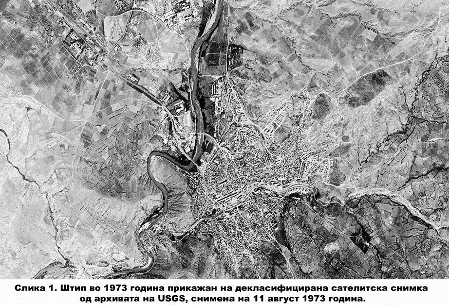
This analysis uses a declassified black-and-white satellite image from the U.S. Geological Survey (USGS) archive, taken on August 11, 1973. The image is part of the Declassified Satellite Imagery / Declass 3 collection and represents a valuable historical record of the area of Shtip and its surroundings.
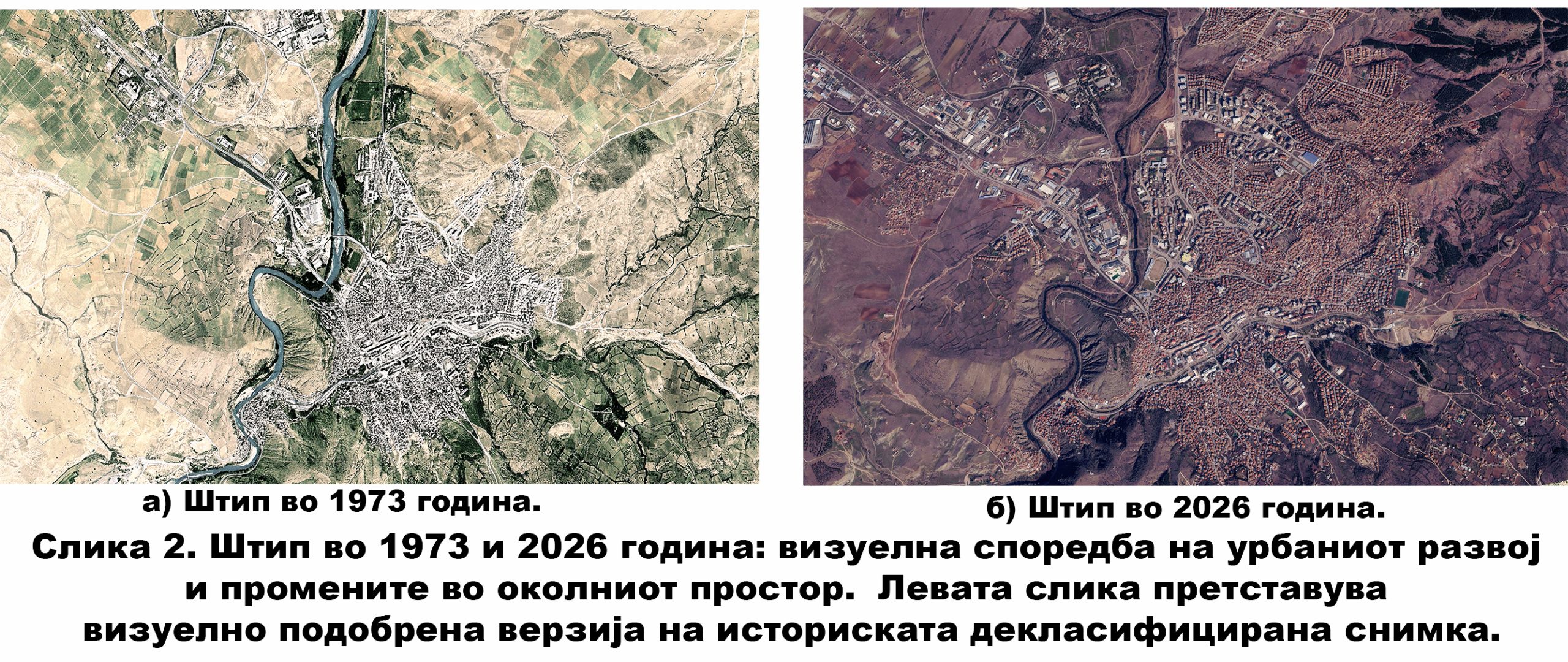
The original image is not a modern georeferenced satellite product. Therefore, the part that includes the city of Shtip was separated, processed and georeferenced in QGIS, using recognizable spatial elements such as riverbeds, road routes, bridges, terrain forms and older urban structures. For easier visual interpretation, the historical black-and-white image was further processed with artificial intelligence algorithms, creating a colored visualization of the space. This version allows for easier recognition of the river, agricultural areas, hilly terrain and urban structure, but the spatial analysis and calculations are based on the original georeferenced image.
How much did Stip expand?
By manually digitizing the built-up area from the georeferenced historical image, an estimate of the urbanized area of Shtip in 1973 was made. The same procedure was applied to a modern satellite image from 2026, which enabled a direct comparison of the spatial development of the city over a period of more than five decades.
The results show that the visibly built-up urban area of Shtip in 1973 was approximately 292 hectares, while in 2026 it reached around 800 hectares. This represents an increase of about 508 hectares, or approximately 174%. In other words, according to this GIS estimate, the built-up area of the city today is about 2.7 times larger than in 1973.
It is important to emphasize that this analysis considers the visually recognizable built-up area from satellite images, and not the entire official city area. According to data from the Municipality of Shtip, the area of the city is 13.5 km², or 1,350 hectares, but this value refers to a more broadly defined urban area and does not mean that the entire area is completely built-up.
Where is the change most visible?
The comparison shows that Shtip has not expanded evenly. The most visible changes are observed in the zones where there are new residential settlements, industrial and infrastructure corridors today, as well as in the peripheral parts where in 1973 open spaces, agricultural land and hilly terrain dominated.
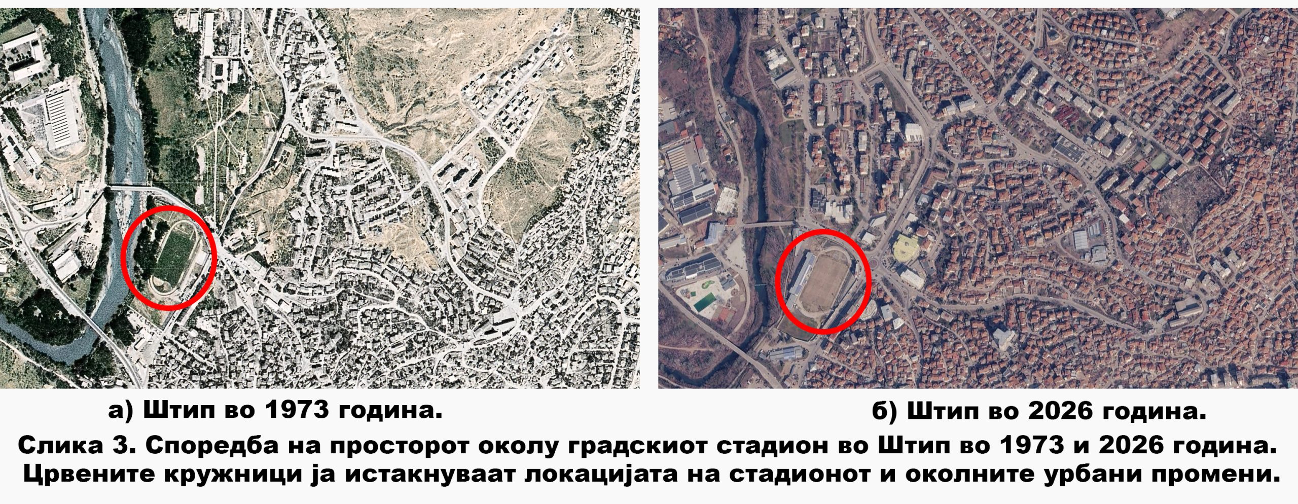
One of the recognizable examples is the area around the city stadium. In the 1973 image, this zone is significantly less built-up, while the 2026 image shows a higher density of buildings, a developed road network and more intensive use of space.
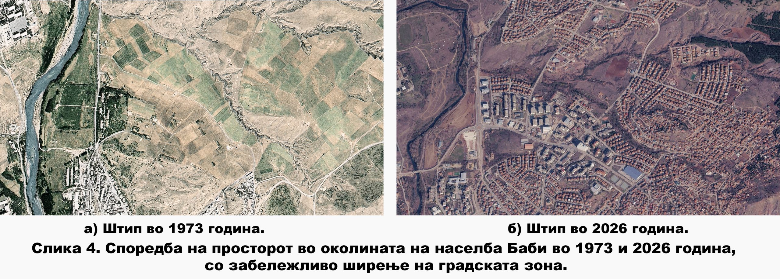
An even more pronounced transformation is observed in the area around the Babi settlement. In 1973, this area was predominantly open and agricultural, with limited construction. Today, the same area is clearly connected to the wider city zone through new residential buildings, streets and infrastructure.
Why is this important?
Declassified satellite images are much more than historical photographs. When combined with GIS tools, georeferencing and modern satellite images, they become a valuable source for analyzing urban and environmental development.
In the case of Shtip, the 1973 image shows us a city with a more compact urban structure, a smaller built-up area and much more open and agricultural space in the immediate vicinity. More than 50 years later, modern satellite imagery shows a significantly expanded urban area, new residential and infrastructure areas, and a changed surrounding landscape.
This comparison is a visual journey through time, but also an example of how modern geospatial technologies can help us better understand the development of our cities.
Prof. Dr. Vancho Adziski
Faculty of Natural and Technical Sciences,
Goce Delcev University – Stip